Microcredential in Geographic Information Systems (GIS)

The Department of Geography introduces the Integrative Curricular Microcredential (“micro”) in geographic information systems (GIS). The first program of its kind at SUNY Geneseo, the micro in GIS teaches skills in emerging geospatial technologies useful to a myriad of disciplines and careers. Students completing this micro will learn how to collect, map, and analyze geospatial data via specialized GIS software. Upon completion of the micro, students will receive a digital badge making their achievement visible to potential employers or graduate schools, shareable via their LinkedIn profile and other social media accounts or websites.
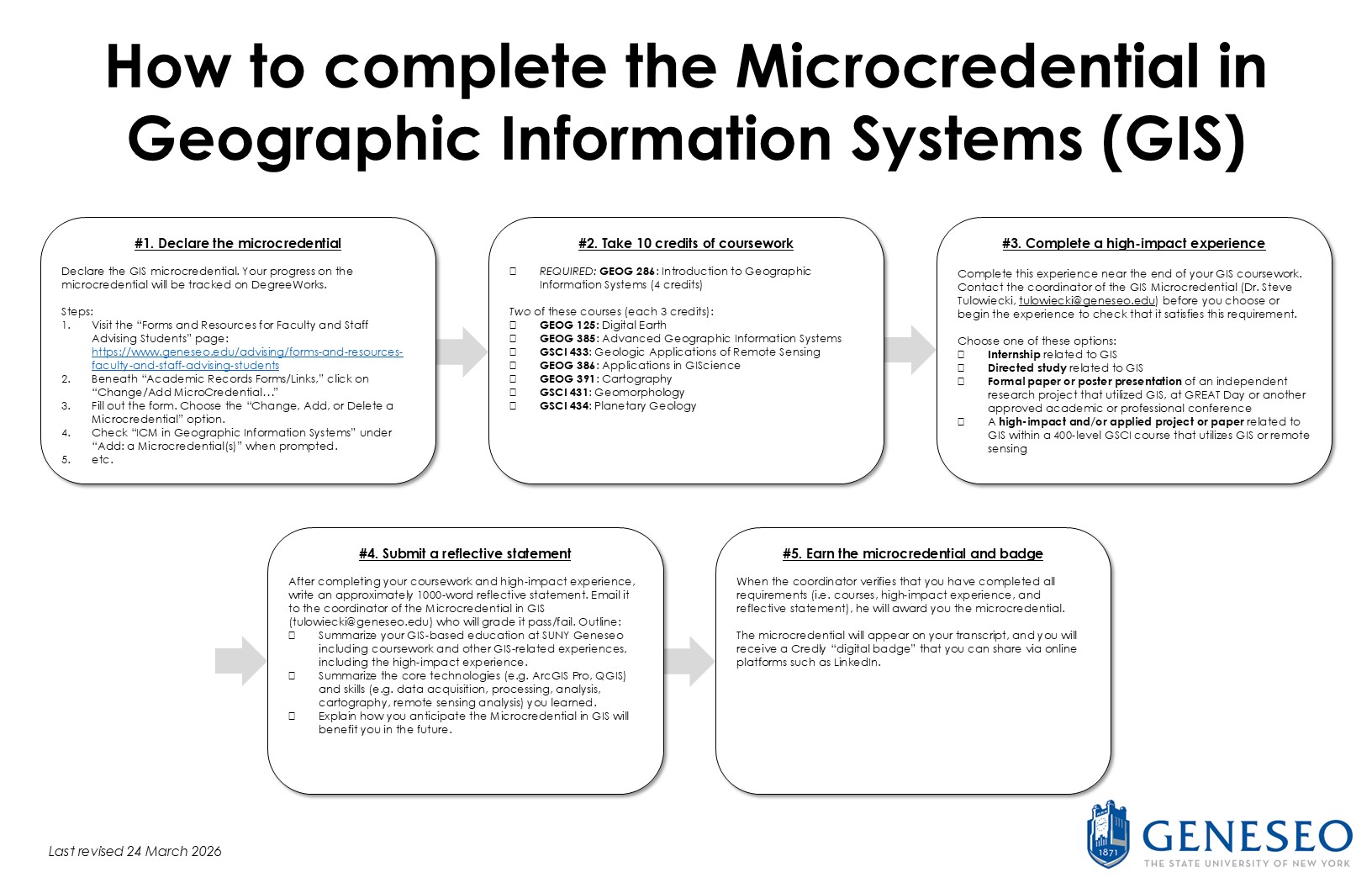
DECLARE THE MICROCREDENTIAL HERE – UNDER “ACADEMIC RECORDS FORMS/LINKS” CHOOSE “CHANGE/ADD MICROCREDENTIAL”: https://www.geneseo.edu/advising/forms-and-resources-faculty-and-staff-advising-students
REQUIREMENTS (Total credits: 10)
- GEOG 286: Introduction to Geographic Information Systems (4 credits)
- Two of the following courses (each 3 credits):
- GEOG 125: Digital Earth
- GEOG 385: Advanced Geographic Information Systems
- GEOG 386: Applications in Geographic Information Science
- GEOG 391: Cartography
- GSCI 431: Geomorphology
- GSCI 433: Geologic Applications of Remote Sensing Imagery
- GSCI 434: Planetary Geology
- High impact experience & culminating experience: one of the following high impact/integrative experiences (must be pre-approved by the program coordinator):
- Internship related to GIS
- Directed study related to GIS
- Formal paper or poster presentation at GREAT Day (or another approved academic or professional conference) of research that utilizes GIS
- A high impact and/or applied project or paper related to GIS from GSCI 431, 433, or 434
- A self-reflective paper: Upon the completion of the above, write an approximately 1000-word reflective statement that will be graded as pass/fail, with the following outline: (a) summarize your GIS-based education at SUNY Geneseo including coursework and other GIS-related experiences, (b) summarize the core technologies (e.g. QGIS, ArcGIS Pro) and skills (e.g. data acquisition, processing, analysis, cartography) you learned, and (c) explain how you anticipate the Micro in GIS will benefit you in the future. Email this paper to the GIS Microcredential program coordinator (Dr. Steve Tulowiecki, tulowiecki@geneseo.edu).
For further information, contact:
Stephen J. Tulowiecki
Bailey Hall 229
E-mail: tulowiecki@geneseo.edu
Phone: (585) 245-6358